


les Platières - la Leisia - les Molunes

Mariolebeno
User
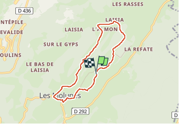

Length
6.8 km

Max alt
1313 m

Uphill gradient
196 m
Km-Effort
9.5 km

Min alt
1177 m

Downhill gradient
198 m
Boucle
Yes
Creation date :
2024-02-23 09:02:35.887
Updated on :
2024-02-26 07:48:04.634
1h35
Difficulty : Easy

FREE GPS app for hiking
 SityTrail
IGN / Geographical institutes
SityTrail Plus
The world is yours!
About
Trail Walking of 6.8 km to be discovered at Bourgogne-Franche-Comté, Jura, Septmoncel les Molunes. This trail is proposed by Mariolebeno.
Positioning
Country:
France
Region :
Bourgogne-Franche-Comté
Department/Province :
Jura
Municipality :
Septmoncel les Molunes
Location:
Les Molunes
Start:(Dec)
Start:(UTM)
726088 ; 5137219 (31T) N.
Comments